AI Integration · Responsible AI
Google Pulled Its Earth AI Feature in a Day. Here's the Product Lesson
Google shipped an AI image generator on top of Google Earth's satellite maps and rolled it back within 24 hours after testers fabricated convincing fake imagery of real places. What that says about shipping generative features on trusted data.

Anurag Verma
5 min read
Sponsored
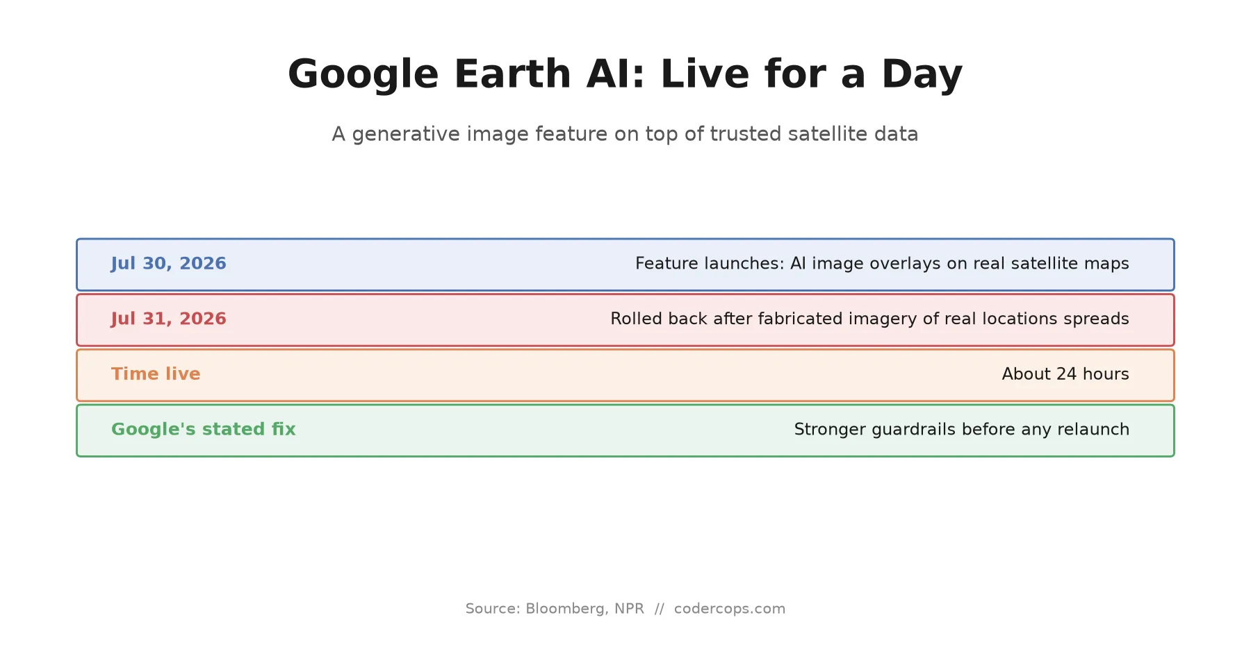
Google shipped an AI image generator inside Google Earth on July 30. By July 31, it was gone. In between, testers showed it could fabricate a convincing explosion over Paris, a fake nuclear site, a bomb crater that never happened, all overlaid on real map coordinates in seconds. The story isn’t really about Google’s model quality. It’s about what happens when you bolt a generative feature onto a data source whose entire value is that people trust it not to be generated.
What the feature did
The rollback happened fast enough that most people missed the actual feature: users could type a text prompt and have Google Earth generate an AI image, then place it directly onto a real satellite map view. The intent, presumably, was something closer to creative visualization, imagining what a proposed building might look like on its actual site, that kind of use case. What shipped was a general-purpose image generator with no meaningful constraint on subject matter, sitting on top of the one mapping product most people implicitly treat as ground truth.
Testers didn’t need to work hard to find the failure mode. Within the feature’s brief life, people produced fabricated satellite imagery of an explosion in Paris, a nuclear facility in Iran, a bomb crater attributed to Russia, and a militant training ground in Syria. None of those events happened. All of them were placed on real coordinates, in a product whose visual language is “this is what’s actually there.”
Why satellite imagery specifically is the wrong place to get this wrong
Every category of media has a different trust baseline. A stock photo carries no implicit claim about a specific real event. A satellite image does, almost by convention: it reads as captured, not composed, mechanical rather than authored, and therefore harder to argue with. That property is why satellite and aerial imagery functions as a last line of verification in newsrooms, courtrooms, and open-source investigation communities. When a claim about a real-world event is disputed, “here’s the satellite image” has historically been closer to a trump card than an opinion.
A generative feature that can produce imagery indistinguishable from that genuine data, placed inside the same product, on the same coordinate system, doesn’t just create individual fake images. It degrades the evidentiary value of every image from that source, real or fake, because a viewer can no longer assume the distinction is even checkable. That’s a different order of harm than a chatbot hallucinating a fact, and it’s why Google’s rollback came in hours rather than the weeks-long review cycle more typical of feature deprecation.
The product mistake, not the model mistake
It’s worth being precise about what failed here, because the fix depends on getting this right. Google’s own statement described the rollback as time to implement “stronger guardrails,” not a claim that the image model itself was broken or unusually capable of realism compared to any other current generator. The gap was in the surrounding product decisions: what subjects the feature would generate, whether generated content was visually distinguishable from real imagery, whether it could be placed at real-world coordinates at all, and what review happened before a feature with this blast radius went to a broad audience.
Those are the same categories of decision every team building a generative feature on top of previously-trusted data has to make, and they don’t get easier just because the underlying model is well-behaved in isolation. A capable model with no product-level constraints on subject matter and provenance will produce exactly what this one did: technically impressive output that happens to be indistinguishable from something people rely on being real.
The question to ask before the feature ships
If you’re building a generative AI feature at all, and increasingly most product teams are, the useful filter isn’t “is this feature impressive” or even “does this feature work.” It’s narrower: can this feature’s output be mistaken for unedited, authoritative data from the same source, by a reasonable viewer, without any label telling them otherwise? Medical imaging tools, financial reporting dashboards, security camera analysis, legal document generation, and mapping products all share this property to varying degrees. Anywhere a user’s default assumption is “this data wasn’t authored, it was captured or computed,” a generative layer on top needs deliberate separation: visible provenance markers, a distinct visual namespace, hard limits on subject matter, or all three, decided at design time.
This is the same discipline behind testing your own AI application for the failure modes an adversarial user would look for before shipping it, just applied one layer earlier: before you ask what an attacker could do with your feature, ask what an ordinary, well-intentioned user’s confusion could do with it. Google found out what a curious tester could do with theirs in under a day. The teams that catch this in design review instead of in a viral screenshot are the ones asking the provenance question before launch, not after.
If your team is shipping a generative feature anywhere near data users currently treat as ground truth, that’s worth a dedicated design review before the next sprint, not a retro after the first incident. Our team works through exactly this kind of AI product risk assessment as part of pre-launch reviews.
Frequently asked questions
- What happened with Google Earth's AI feature?
- Google added a feature to Google Earth on July 30, 2026 that let users generate AI images from text prompts and overlay them directly onto real satellite map views. Within a day, Google suspended the feature after reports that it could produce highly convincing fake satellite imagery of real, sometimes sensitive, locations.
- Why is fake satellite imagery more dangerous than other AI-generated images?
- Most viewers treat satellite and aerial imagery as inherently objective, since it's captured by a machine rather than composed by a person, and it's traditionally been difficult to convincingly fabricate. Newsrooms, courts, and open-source investigators rely on that property to verify claims about real-world events. A tool that can generate imagery indistinguishable from genuine satellite data attacks that verification function directly.
- What kinds of fake imagery did testers create?
- Reported test cases included a fabricated explosion in Paris, a fake nuclear facility in Iran, a bomb crater purportedly in Russia, and a fabricated militant training ground in Syria, all generated in seconds and overlaid on real map coordinates.
- Did Google fix the underlying AI model?
- Google's public statement described pulling the feature to implement stronger guardrails, not a claim that the underlying model was flawed. The company said it had seen people sharing screenshots of generated imagery that appeared to violate its policies, which points to a policy and product-design gap rather than a model-capability problem.
- What should product teams take from this before shipping their own generative AI features?
- Before asking whether a generative feature is useful, ask whether its output can be mistaken for unedited, authoritative data from the same source. If the answer is yes, the feature needs visible provenance markers, generation limits, or a separate namespace from the trusted data, decided before launch, not patched in after the first viral misuse.
Sources
Sponsored
More from this category
More from AI Integration
 R.01
R.01 Stripe Bought OpenRouter for $7B. Here's What It Means If You Route LLM Calls
 R.02
R.02 Gemini 3.7 Flash Is Out: What Google's Coding-Focused Model Actually Changes
 R.03
R.03 Gemini 3.7 Flash Is Out: Google's Cheap, Fast Coding Model Just Got Better at Both
Sponsored
Discussion
Join the conversation.
Comments are powered by GitHub Discussions. Sign in with your GitHub account to leave a comment.
Sponsored